Tour.

- Miles: 35,000+
- Time: 3 to 6 months
- Start: Anywhere on loop
- End: Anywhere on loop
- Destination: 24 different countries in Africa
- Suitability: adventure bike (some roads can be ridden on with any bike but some are unpaved)
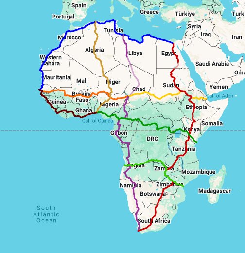
The Trans-African Highway (TAH) network comprises transcontinental road projects in Africa being developed by the United Nations Economic Commission for Africa (UNECA), the African Development Bank (ADB), and the African Union in conjunction with regional international communities. They aim to promote trade and alleviate poverty in Africa through highway infrastructure development and the management of road-based trade corridors.
The total length of the nine highways in the network is 35,221 miles (56,683km).
The network will pass through the following 24 countries:
In some documents the highways are referred to as “Trans-African Corridors” or “Road Corridors” rather than highways. The name Trans-African Highway and its variants are not in wide common usage outside of planning and development circles, and as of 2014 one does not see them signposted as such or labelled on maps, except in Kenya and Uganda where the Mombasa–Nairobi–Kampala–Fort Portal section (or the Kampala–Kigali feeder road) of Trans-African Highway 8 is sometimes referred to as the “Trans-Africa Highway”.
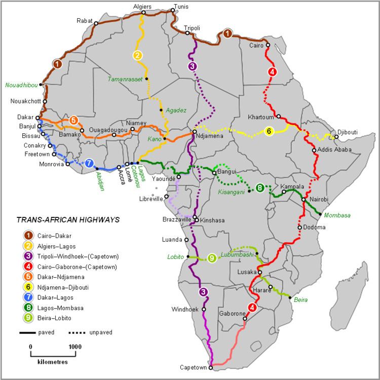
| TAH 1 | Cairo-Dakar Highway | Extending from Cairo, Egypt to Dakar, Senegal, covering North Africa’s Mediterranean coast and West Africa’s Atlantic coast. |
| TAH 2 | Algiers–Lagos Highway | Connecting Algiers, Algeria to Lagos, Nigeria, this route traverses the Sahel region. |
| TAH 3 | Tripoli–Cape Town Highway | From Tripoli, Libya to Windhoek, Namibia, passing through countries like Chad and Angola. |
| TAH 4 | Cairo-Cape Town Highway | Perhaps the most ambitious, linking Cairo, Egypt to Cape Town, South Africa, covering the length of the continent. |
| TAH 5 | Dakar-Ndjamena Highway | Connecting Senegal to Chad across the Sahel. |
| TAH 6 | Ndjamena-Djibouti Highway | Linking Chad to Djibouti, facilitating access to the Red Sea. |
| TAH 7 | Dakar-Lagos Highway | A coastal highway connecting West African nations from Senegal to Nigeria. |
| TAH 8 | Lagos-Mombasa Highway | Spanning from Lagos, Nigeria to Mombasa, Kenya, crossing Central Africa. |
| TAH 9 | Beira-Lobito Highway | Connecting Beira, Mozambique to Lobito, Angola, facilitating east-west trade in Southern Africa. |

East-west routes
Starting with the most northerly, the east–west routes are:
- Trans-African Highway 1 (TAH 1), Cairo–Dakar Highway, 5,366 miles (8,636 km): a mainly coastal route along the Mediterranean coast of North Africa, continuing down the Atlantic coast of North-West Africa; substantially complete, although the border between Algeria and Morocco is closed. TAH 1 joins with TAH 7 to form an additional north–south route around the western extremity of the continent. Connects with M40 of the Arab Mashreq International Road Network.
- Trans-African Highway 5 (TAH 5), Dakar–N’Djamena Highway, 2,794 miles (4,496 km): also known as the Trans-Sahelian Highway, linking West African countries of the Sahel, about 80% complete.
- Trans-African Highway 6 (TAH 6), N’Djamena–Djibouti Highway, 2,622 miles (4,219 km): contiguous with TAH 5, continuing through the eastern Sahelian region to Indian Ocean port of Djibouti. The approximate route of TAH 5 and TAH 6 was originally proposed in the early 20th century as an aim of the French Empire.
- Trans-African Highway 7 (TAH 7), Dakar–Lagos Highway, 2,490 miles (4,010 km): also known as the Trans–West African Coastal Road, about 80% complete. This highway joins with TAH 1 to form an additional north–south route around the western extremity of the continent.
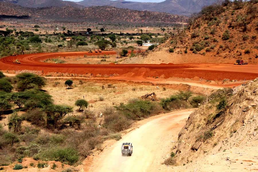
- Trans-African Highway 8 (TAH 8), Lagos–Mombasa Highway, 3,889 miles (6,259 km): which is contiguous with TAH7 and forms with it a 10,269-km east–west crossing of the continent. The Lagos–Mombasa Highway’s eastern half is complete through Kenya and Uganda, where locally it is known as the Trans-Africa Highway (the only place where the name is in common use). Its western extremity in Nigeria, Cameroon and Central African Republic is mostly complete but a long missing link across DR Congo currently prevents any practical use through the middle section.
- Trans-African Highway 9 (TAH 9), Beira–Lobito Highway, 2,189 miles (3,523 km): substantially complete in the eastern half but the western half through Angola and south-central DR Congo requires reconstruction.
North-south routes
Starting with the most westerly, these are:
- Trans-African Highway 2 (TAH 2), Algiers–Lagos Highway, 2,799 miles (4,504 km): also known as the Trans-Sahara Highway: substantially complete, only 120 miles (200 km) of desert track remains to be paved, but border and security controls restrict usage.
- Trans-African Highway 3 (TAH 3), Tripoli–Windhoek–(Cape Town) Highway, 6,716 miles (10,808 km): this route has the most missing links and requires the most new construction, as only national paved roads in Libya, Cameroon, Angola, Namibia and South Africa can be used to any extent. South Africa was not originally included, as the highway was first planned in the Apartheid era, but it is now recognized that it would continue to Cape Town.
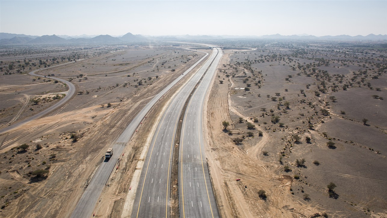
- Trans-African Highway 4 (TAH 4), Cairo–Gaborone–(Pretoria/Cape Town) Highway, 6,355 miles (10,228 km): the completion of the stretch of highway from Dongola to Abu Simbel Junction in Northern Sudan and the road from the Galabat border crossing in North-Western Ethiopia leaves no section unpaved; the road section between Babati and Dodoma in central Tanzania was completed in May 2018. The section between Isiolo and Moyale in northern Kenya (dubbed ‘the road to hell’ by overland travellers) has recently been completed creating a smooth crossing across Kenya. Crossing the Egypt-Sudan border by road has been prohibited for a number of years, a vehicle ferry on Lake Nasser is used instead. As with TAH 3, South Africa was not originally included as the idea was first proposed in the Apartheid era, but it is now recognized that it would continue to Pretoria and Cape Town. Except for passing through Ethiopia, the route roughly coincides with proposals for the Cape to Cairo Road put forward in the early 20th century British Empire.
As noted above, TAH 1 and TAH 7 join to form an additional north–south route around the western extremity of the continent between Monrovia and Rabat.